Defense, Intelligence & Security
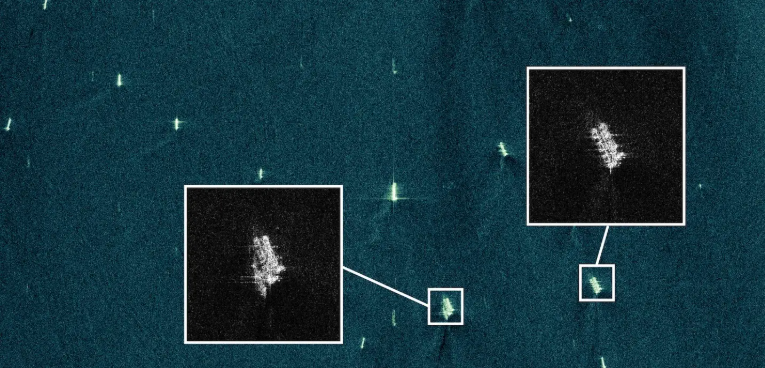
Enhanced Target Detection & Classification of vessels, vehicles or aircraft, these are highly demanded in intelligence and defense environments.
Maritime Domain Awareness which identifies vessels, including ships that are involved in covert operations, illegal or smuggling actions, unreported and unregulated fishing etc.
Border Monitoring which uses a wide-area coverage and high resolution imaging to detect suspicious cross-border activity.
Strategic Site Surveillance that detects subtle changes at military bases, ports or launch sites using ultra high resolution data.
Sovereign Capabilities that helps allied nations operate and build their own dedicated SAR constellations & missions.
Source: Maritime Domain Awareness, ICEYE (https://www.iceye.com/sar-data/use-cases/maritime-domain-awareness)
Natural Catastrophe Response & Recovery
Natural Catastrophe Response & Recovery including services for humanitarian relief such as helping rescue teams and providing data for the insurance sector.
Oil Spill Monitoring
General High-Frequency Change Detection that is critical for detecting & responding to real events
Flood Monitoring that provides near real-time flood data.
Sea Ice Monitoring that ensures the efficiency & safety of offshores operations by providing reliable data on ice conditions, movements, & iceberg locations for shipping routes, especially in polar regions.
Climate Change Monitoring is used by researchers for the identification of changes in sea & terrestrial ice formations in the Antarctic & the Arctic, providing reliable & detailed info on ice formations & movement over time.
Volcanic Eruption Monitoring is used for daily observations of lava flow and fissure openings, allowing for the creation of underlying predictive models based on the daily observations.
Deforestation Monitoring is used to oversee forested areas and to detect any illegal logging activities, even in heavily clouded areas like the Amazon.
Source: "ICEYE Supports the European Maritime Agency with Satellite data", Defense Industry Europe (https://defence-industry.eu/iceye-supports-the-european-maritime-safety-agency-with-sar-satellite-data/)
Commercial & Other Industries
Insurance & Finance Sector which includes flood insights & claims triage, this provides building-level flood extend and inundation measurements within 24 hours of a flood peak. Due to this the claims triage is accelerated and this improves damage & loss estimation, & allows for faster resource and relief allocation. There is also a Flood Early Warning that alerts the interested companies can obtain and they are given based on pre-flood intelligence such as forecasted location, intensity of an event and its likelihood. Satellites also give a Hurricane Solution by delivering impact info for both wind & flooding within hours of hurricane landfall, pinpointing areas of major building impact to inform adjuster allocation & reduce claims costs.
Regarding the financial sector high - resolution data can be used for detailed volume monitoring of stockpiles and vehicle count monitoring for economic analysis.
Energy, Utilities, Mining and Infrastructure:
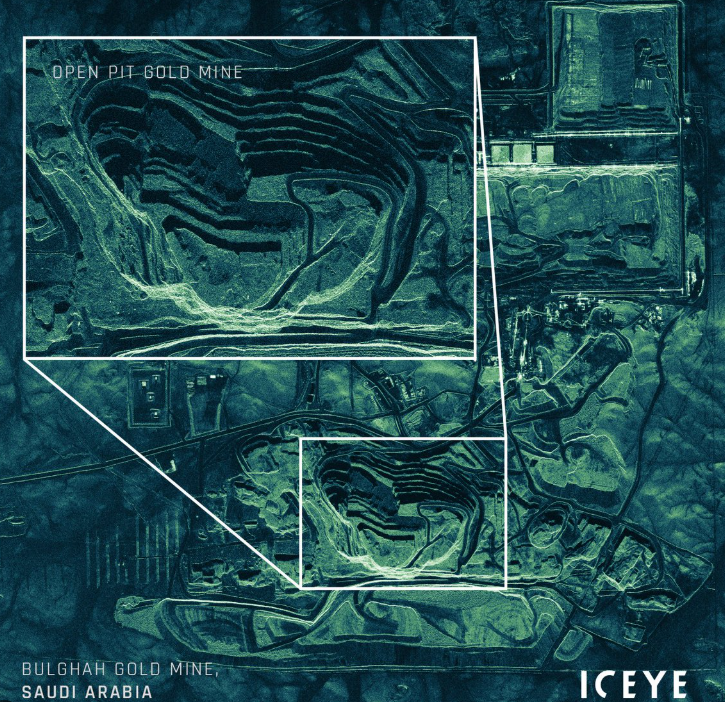
Mining & Energy uses ICEYE satellites for the monitoring of open pit mines, oil & gas refineries, and electric transmission networks for stability & security and it also helps to monitor potentially dangerous ground subsidence.
Infrastructure
Civil Governments & Public Sector Organizations get supported with time-critical situational awareness & emergency response data. Satellites also provide actionable intelligence on port operations nationwide including tracking vessels activity & capacity/inventory monitoring.
Source: post on X website, (https://x.com/iceye_global/status/1387798144688312322)