US Federal Emergency Management Agency (FEMA)
The Federal Emergency Management Agency (FEMA) is responsible for leading the federal government’s efforts in disaster preparedness and response. Its work includes planning for emergencies, reducing risks, responding to crises, and supporting recovery efforts after both natural and human-caused disasters.
For over 15 years, New Light Technologies (NLT) has supported FEMA by delivering IT modernization solutions and operational technical services. Their work helps FEMA gather, analyze, and share information from multiple sources so that leaders can make informed decisions during major incidents and national emergencies.
Since 2021, ICEYE has partnered with NLT to provide FEMA with satellite-based Flood Insights. These services enhance FEMA’s ability to monitor and assess flooding events, supporting its mission to assist communities before, during, and after disasters.
In recent years, FEMA has used Flood Insights to access observation-based data on flood extent and water depth for almost two dozen major flood incidents. These events have ranged from sudden flash floods and prolonged atmospheric river systems to large-scale hurricanes.
By combining ICEYE’s satellite-derived flood data with NLT’s IT and operational support, FEMA has strengthened its ability to respond effectively. This has allowed the agency to prioritize urgent actions such as deploying Urban Search and Rescue Task Forces, accelerating preliminary damage assessments and disaster declarations, and improving overall situational awareness during major flooding events. It has also supported better coordination of airborne imagery collection and the documentation of high-water mark locations on the ground.
The Issue
During disaster response operations, one of FEMA’s key systems is the Tool for Emergency Management Prioritization & Operations (TEMPO). This decision-support platform, developed by NLT for FEMA, is designed to assist the agency in assessing risks and allocating resources effectively during emergencies.
TEMPO integrates real-time hazard information with foundational datasets and geospatial analysis to provide a clearer understanding of how disasters affect communities and infrastructure. This enables FEMA to make informed decisions about prioritizing response efforts. A crucial component of TEMPO’s analytical model is ICEYE’s Flood Insights, which supplies detailed information on the scope, intensity, and impacts of flooding, particularly on vulnerable populations and critical infrastructure.
Although FEMA had successfully used Flood Insights and TEMPO in recent years to manage a number of declared disasters, the 2024 Atlantic hurricane season brought a new level of difficulty. The season proved to be exceptionally active and highly destructive, creating challenges that tested existing response systems.
The season generated 18 named storms, 11 of which intensified into hurricanes. Five of those hurricanes made landfall, falling just short of the historical record. Hurricane Milton hit Florida’s west coast less than two weeks after Hurricane Helene had already caused significant destruction in the state’s Big Bend region.
The back-to-back impact of these storms placed considerable strain on federal, state, and local agencies, stretching available resources for both response operations and recovery efforts.
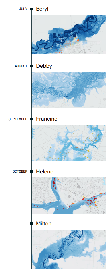
Hurricane Season of 2024
Beryl, July 2024:
Hurricane Beryl was the first storm of the season to make landfall. Before reaching the coast, it made history over open waters by becoming the earliest recorded Category 5 hurricane. However, it weakened to a Category 1 storm by the time it struck the Texas coastline.
Despite the downgrade, Beryl still caused significant destruction. Powerful storm surge, record-breaking rainfall, and intense wind gusts led to widespread damage in Texas. As the storm system moved inland, its remnants continued to impact regions across the Mississippi and Ohio Valleys, the Great Lakes, New England, and even parts of Canada, ultimately resulting in several dozen deaths.
Debby, August 2024:
Hurricane Debby was another significant storm during the 2024 season, making landfall in August. Because it moved slowly across the region, the storm produced near-record levels of rainfall. Heavy precipitation affected areas from Florida through the Carolinas and extended into the Northeast and parts of southern Canada.
At the height of the event, more than 35 million people—from Florida to Vermont—were under flood watches or warnings, highlighting the widespread impact of the storm.
Francine, September 2024
Hurricane Francine made landfall on September 11 as a Category 2 storm. The hurricane brought significant storm surge along with more than six inches of rainfall in New Orleans and nearby areas. These conditions led to flooding across parts of Louisiana and Mississippi, contributing to widespread local impacts.
Helene, October 2024:
Hurricane Helene proved to be the most devastating storm of the season. It began by generating record-breaking storm surge that flooded hundreds of miles of Florida’s coastline, affecting hundreds of thousands of residents.
After making landfall, the storm brought more than 48 hours of continuous rainfall, leading to catastrophic flooding across several states, including Georgia, North Carolina, South Carolina, Tennessee, and Virginia. In some areas, rainfall totals in less than two days matched or even exceeded what is typically expected for an entire year.
Milton, 2024:
Less than two weeks after Hurricane Helene struck Florida, Hurricane Milton made landfall along the state’s coastline. The storm brought severe storm surge to parts of Southwest Florida, along with powerful hurricane-force winds that swept across much of the peninsula.
In addition to coastal impacts, heavy rainfall led to significant freshwater flooding, which continued for more than a week after the storm initially hit. The back-to-back nature of these events further intensified the strain on response and recovery efforts throughout the state.
Source: ICEYE x NTL x FEMA, ICEYE (https://www.iceye.com/resources/case-studies)
The Solution Provided by ICEYE
ICEYE has worked with NLT to provide FEMA with flood and hurricane insights since the 2021 Atlantic Hurricane Season, beginning with Hurricane Ida. However, the scale and intensity of the 2024 disasters meant that NLT and ICEYE were asked to deliver information at a pace and speed that had not been tested in previous seasons.
Working alongside NLT, ICEYE was able to provide FEMA with initial flood insights in under 24 hours after each flood reached its peak. This rapid delivery was made possible by ICEYE’s Synthetic Aperture Radar (SAR) technology, which can capture data through clouds, at night, and across the globe multiple times per day.
The flood data was processed, visualized, and shared through TEMPO, giving FEMA and the broader disaster management community essential information. These insights were widely used to guide response and recovery efforts across the affected regions.
Results
Flood Insights served as a key data source in approving disaster declarations for all five landfalling hurricanes—Beryl, Debby, Francine, Helene, and Milton. In the cases of Hurricanes Helene and Milton, the declarations were processed at nearly record speed, thanks to the ICEYE and NLT collaboration, which delivered actionable intelligence to FEMA via TEMPO.
Beyond providing essential situational awareness and accelerating disaster declarations, the data was also used to:
- Allocate resources for response and recovery, including the distribution of critical emergency supplies
- Prioritize emergency operations, such as conducting damage assessments and coordinating search and rescue missions
- Evaluate the real-time impact of flooding on businesses and infrastructure
- Provide leadership with timely updates through internal briefings
- Determine the most efficient routes for aerial imagery collection by agencies like NOAA
-
Validate predictive models and support the evaluation of floodplain management strategies