In Depth Look
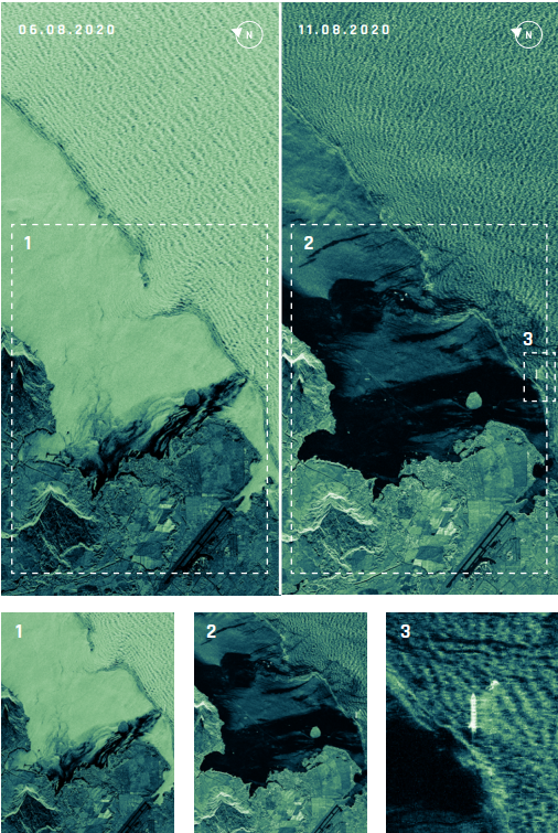
The ICEYE imagery depict the progression of the oil spill off the shore of Mauritius in August 2020 that was caused by a bulk carrier that ran around on a coral reef. The data on 6th of August 2020 was taken during nighttime which combined with SAR being able to operate in all-weather conditions gives the SAR technology an advantage when it comes to persistent monitoring.
The displayed ICEYE imagery depicts the change in extent of the oil spill over a week-long period, as well as the direction in which the oil spill has been carried away by the sea currents. The vessel that caused this ordeal is clearly displayed as well, tracked down by the oil spilling out of it.
Source: 'Detect & Respond to Oil Spills', ICEYE (https://www.iceye.com/sar-data-applications/oil-spills/thank-you-download-oil-spills?submissionGuid=ed02e381-97b7-46d6-98dc-c58a6a4dcb8e)
Image 1: The extension of how much the oil spread along the shoreline in less than 2 weeks after the vessel ran aground on a coral reef. As one can detect, the oil spill spread mostly northwest. The extension of the spill is estimated about 3 km².
Image 2: Data obtained seven days after the previous imagery depict that the extent of the spill has spread north along the shoreline, covering 10 times more area than the previous week.
Image 3: In this imagery the bulk carrier MV Wakashio is depicted with a visible oil slick spreading out towards the shoreline.
ICEYE SAR Data Can:
Identify Vessels Responsible for Oil Spills
Detect Small & Large Oil Spills
Get Frequent Situational Updates on Oil Spill Extent Progression
Detect Oil Spills from Oil Platforms
Interested in Reading More?
Please visit the link below to find out more about ICEYE's missions