Introduction to SAR
Synthetic Aperture Radar or SAR is a type of radar technology used to create highly detailed images of the Earth's surface regardless of daylight or weather conditions. Compared to optical sensors, which rely on clear skies and sunlight, SAR systems actively send out microwave signals and then record the reflections that bounce back from the ground. At it's core SAR provides all weather, day-and-night imaging, high resolution detail and surface information beyond what the eye sees including texture, moisture levels and movements. All the above make SAR a powerful tool because it operates without any environmental restrictions.
ICEYE press release, “ICEYE’s 3 Newest Satellites Return First Radar Images” (iceye.com/newsroom/press-releases/iceyes-3-newest-satellites-return-first-radar-images).
History of SAR systems
Synthetic Aperture Radar (SAR) started as an idea during World War II, when scientists were trying to overcome the limits of traditional radar antennas. By using the movement of an aircraft to 'extend' the antenna, they created much sharper radar images and thus the foundation for SAR technology was laid. In 1970 the first spaceborne SAR images were created with NASA's Seasat, which showed how radar could map oceans, land and ice from space. The decades that followed were focused on missions from Europe, Canada, United States and Japan, advancing the technology and proving its value for Earth monitoring in any weather, day or night. In recent years, SAR has been made more accessible, faster and more detailed than ever with the launch of smaller satellites by space agencies and private companies. Today, Synthetic Aperture Radar is used worldwide to track environmental change, support disaster response and monitor infrastructure & security, making it one of the most powerful tools for Earth observation.
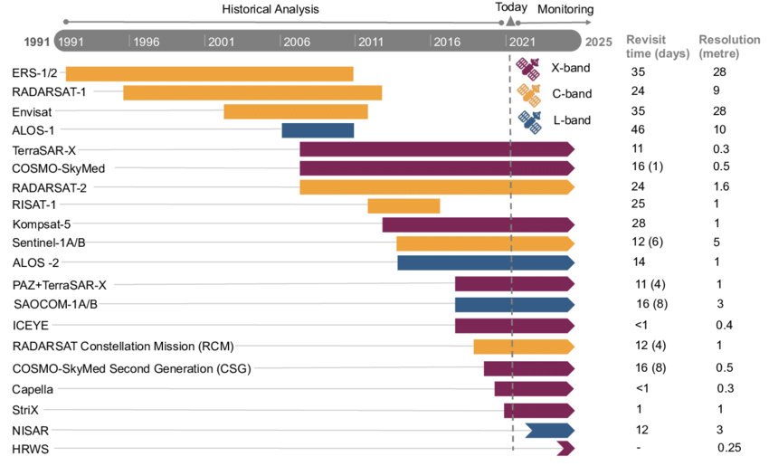
Timeline of SAR satellite missions (1991–2025). Adapted from ESA (2021) & Flores-Anderson et al. — published on ResearchGate.
Source: ResearchGate — “Timeline of past, present and future SAR missions”(https://www.researchgate.net/figure/Timeline-of-past-present-and-future-SAR-missions-between-1991-and-2025-and-their-main_fig2_356791826)
SAR Imaging principles
Synthetic Aperture Radar is an active remote sensing technology that creates high-resolution images using radar signals. Furthermore, SAR sends microwave pulses towards the ground and measures echoes that bounce back. As the name of the tool states it, the core idea is synthetic aperture: as the radar platform (aircraft or satellite) moves, it collects multiple echoes over time. The combination of these signals, SAR simulates a much larger antenna than physically exists improving image resolution. In SAR imaging two main concepts are critical, the Range Resolution & the Azimuth Resolution. Range Resolution is defined as the ability to distinguish objects at different distances from the radar, determined by the pulse duration & bandwidth. Azimuth Resolution is the ability to distinguish objects along the flight path, achieved by synthesizing the long antenna aperture from the platform's motion. At last, the resulting image can reveal textures, changes and surface features with high detail, even through clouds or at night, deeming them invaluable for Earth observation, environmental monitoring, mapping and defense application.
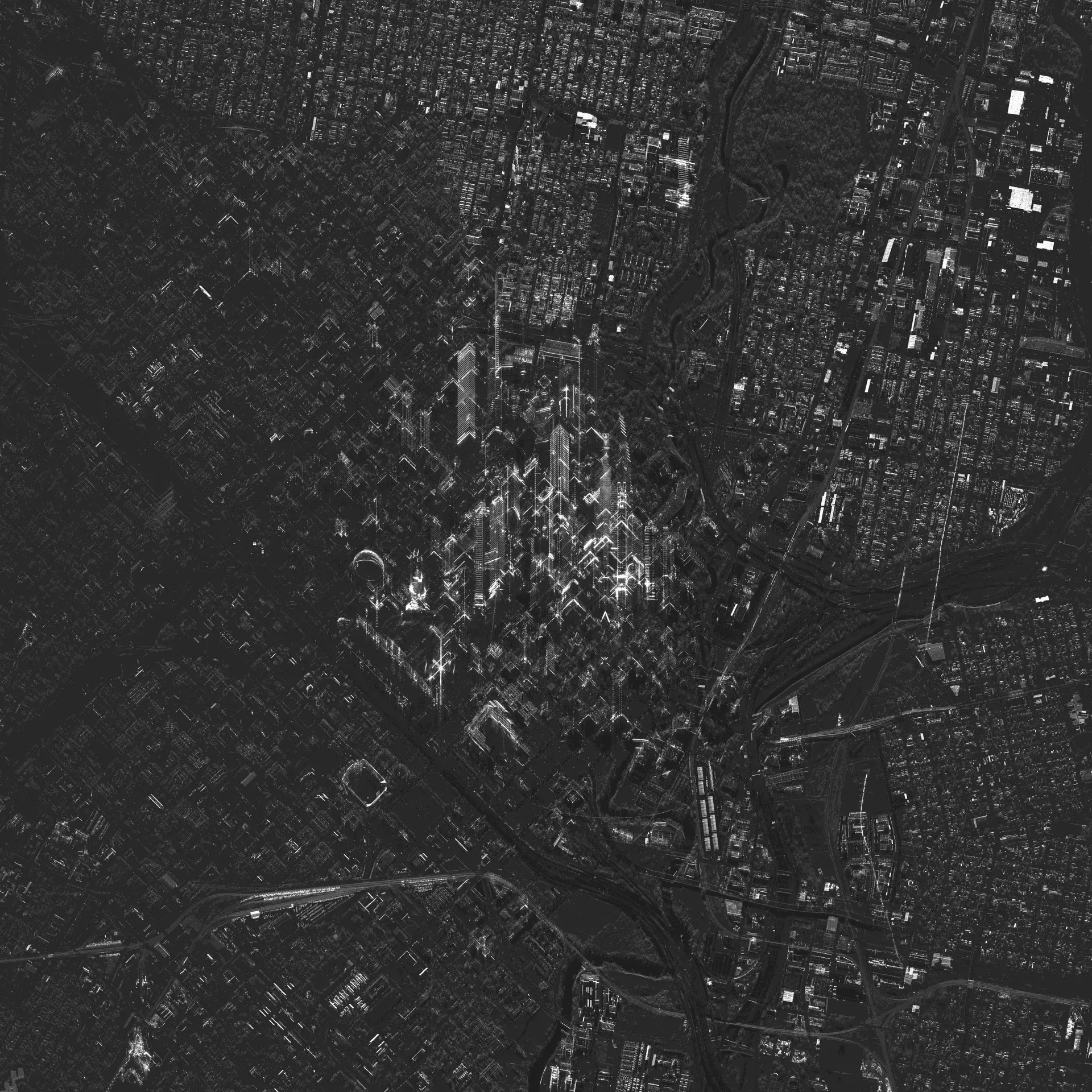
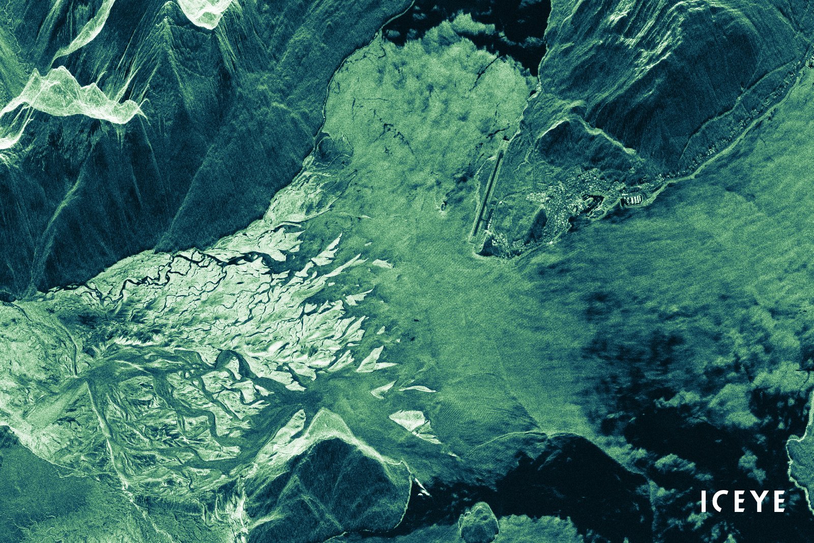
Source: SAR image of Houston, USA taken by an ICEYE satellite (https://www.iceye.com/resources/datasets)
SAR Frequency Bands
The operation of Synthetic Aperture Radar (SAR) systems operate at different microwave frequency bands, each with unique characteristics that affect resolution, application and penetration. The most common bands are:
- X-band (8-12 GHz): High resolution, but limited penetration through soil or vegetation. Often used for infrastructure monitor and urban mapping.
- C-band (4-8 GHz): Balanced resolution & penetration. Widely used for maritime surveillance, environmental monitoring and disaster management.
- L-band (1-2 GHz): Longer wavelength allows for deeper penetration through ice, soil and vegetation. It's ideal for soil moisture studies, geological mapping and forestry.
- P-band (0.3-1 GHz): Very long wavelength with excellent penetration, mainly used in scientific & research applications, such as subsurface studies and archeology.
Selection of a SAR band is dependent on the target, resolution needs and environmental conditions.
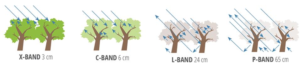
Source: NASA Earthdata — ‘Synthetic Aperture Radar (SAR),’ frequency bands illustration (https://www.earthdata.nasa.gov/learn/earth-observation-data-basics/sar)
SAR Polarizations
SAR systems can transmit & receive radar signals in different polarizations, which describe the orientation of the electromagnetic waves. The most common polarization types include:
- HH (Horizontal transmit, Horizontal Receive): Sensitive to surface roughness; often used for land mapping.
- V V (Vertical transmit, Vertical receive): Good for moisture & vegetation structure detection.
- HV / VH (Cross-polarized): Transmit in one orientation and receive in the perpendicular. Highlights scattering from complex targets like urban areas or forests.
The use of different polarizations gives the ability to SAR to extract more information about the surface such as built structures, vegetation type and soil moisture, making it a versatile tool for environmental, urban and agricultural monitoring.
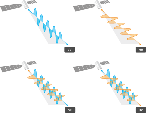
Source: Esri / ArcGIS Pro — “Introduction to Synthetic Aperture Radar: Polarization” (https://pro.arcgis.com/en/pro-app/latest/help/analysis/image-analyst/introduction-to-synthetic-aperture-radar.htm)
SAR Acquisition modes
SAR has the ability to operate in several acquisition modes, each designed for different imaging needs:
Stripmap Mode: The radar points straight ahead as the satellite moves, creating long, continuous images with moderate resolution. Useful for wide-area mapping.
Spotlight Mode: The beam of the radar is focused on a specific area for a longer time, improving resolution but reducing coverage. Best for detailed imaging of a small region.
ScarSAR Mode: The radar rapidly switches between multiple subswaths to cover a much larger area and in exchange some resolution for broader coverage is sacrificed.
Doppler-Beam Sharpening / Dwell Mode: Advanced modes that increase resolution by combining multiple passes or focusing on a stationary area. Most used in commercial constellations for near-real time monitoring.
Each mode has a balance of coverage and resolution depending on the task's requirements, deeming SAR highly flexible for environmental monitoring, disaster response, infrastructure inspection and defense applications.
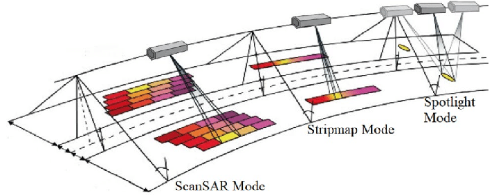
Source: APSI Co., Ltd. (https://www.apsi.co.kr/en/sub/sub03_02.php)
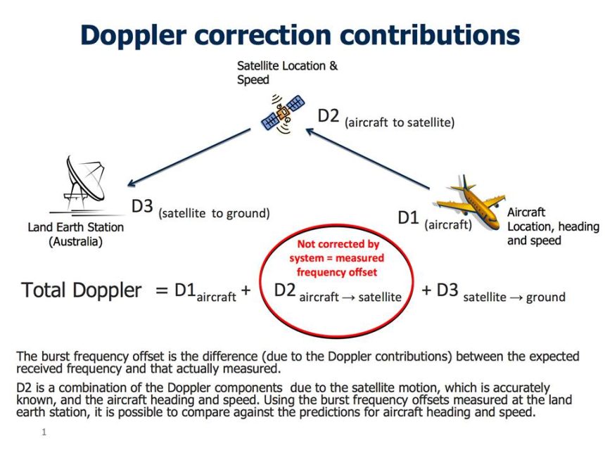
Doppler & SAR
The Doppler effect is the change in observed frequency of a wave due to relative motion between the transmitter and the target.
Practically, if the SAR satellite moves towards the target then the frequency appears higher. When the SAR satellite moves away from the target the frequency appears lower.
In Synthetic Aperture Radar, the radar antenna moves along its flight path (whether it's a satellite or aircraft the same principles apply). Each ground target reflects the radar pulse, but because the platform is moving, the frequency of the returned signal changes slightly over time due to the Doppler effect.
SAR uses this Doppler effect frequency change to:
- Distinguish targets along the azimuth (flight) direction
- Synthesize a large antenna aperture
- Improve resolution far beyond the physical antenna length
This is one of the reasons that it's called "Synthetic Aperture", because the motion of the sensor and the Doppler history of each pixel "build" a much larger effective antenna.
Doppler Frequency & Geometry
The Doppler frequency in SAR Geometry plays an important part in this process. Imagine the satellite flying at a constant velocity and transmitting pulses at regular intervals:
- When the target is ahead of the radar then relative motion is toward the sensor and there is a positive doppler shift
- When the radar is directly abeam the target then there is no doppler shift (zero Doppler point)
- When the radar moves past the target and relative motion is away then there is a negative doppler shift
That continuous change in Doppler frequency over time creates a Doppler History, a curve that looks like a chirp. SAR processing uses this Doppler history to focus the image.
Doppler Centroid Frequency
The Doppler centroid frequency represents the average Doppler shift for all echoes in a scene. It's dependent on:
- Sensor Velocity
- Look Angle
- Earth Rotation (for satellites)
- Target motion
The current estimation the centroid frequency is crucial for:
- Precise focusing of the SAR image
- Co-registration in Interferometry (InSAR)
- Geolocation accuracy
If the doppler centroid frequency is misestimated then the images appear defocused or shifted in azimuth.
Azimuth Resolution (Along-Track)
In radar imaging, azimuth refers to the direction along the satellite's flight path. Normally, the resolution in that direction would depend on the size of the physical antenna, a smaller antenna would blur the features together.
SAR turns the Doppler frequency shifts, caused by the satellite's motions, into a powerful advantage. As the satellite moves, it collects echoes from each target over time, each with slightly different Doppler shifts.
The combination of all these echoes coherently, a much larger antenna is simulated, a synthetic aperture as mentioned above.
The result:
- Very high azimuth (along-track) resolution, far better than what the physical antenna could achieve
- The resolution becomes independent of range. Objects far form the satellite are just as sharp as those closer.
Doppler & Moving Targets
If a target moves such as a ship or a car:
- It's radial velocity adds to the Doppler Shift
- In a SAR image, it appears displaced or smeared (azimuth shift or defocus). That's the basis of Ground Moving Target Indication (GMTI) & Ship Detection using Doppler Anomalies. The above are all techniques one may use in shipwreck/maritime studies.
Source: The Aviationist. (https://theaviationist.com/2014/03/27/inmarsat-helps-finding-route/)
Use cases & applications
Maritime awareness & ocean monitoring, Disaster monitoring, Agriculture, Infrastructure monitoring, Environmental & Hazard monitoring, Natural Catastrophe & Disaster monitoring, Defense & Geopolitical support, Strategic site & Border Monitoring, Security Surveillance.
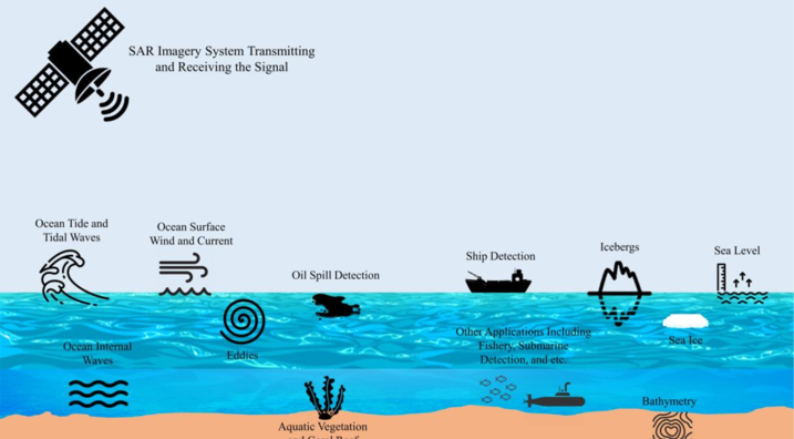
Source: An overview of different oceanographic applications of SAR systems,” in “Synthetic Aperture Radar (SAR) for Ocean: A Review”, Reza M. Asiyabi et al., ResearchGate (https://www.researchgate.net/figure/An-overview-of-different-oceanographic-applications-of-SAR-systems_fig3_373543811)